Wednesday 14th Mar 2018
In conjunction with our clients from Groupement Sonatrach-AGIP, Badley Ashton are presenting a paper at NAPEC 2018. NAPEC 2018 is the largest oil and gas exhibition and conference in Africa and will be held in Oran, Algeria and runs from the 25th to the 28th of March. If you would like to find out more information, please click on the link below.Entitiled ” Refining static models through an integrated approach to reservoir description: a case study from the fluvially-dominated Triassic Argilo-Gréseux Inférieur (TAGI) Formation, Berkine Basin, Algeria “, the abstract is given below. This is based upon work from a recent project undertaken by Badley Ashton on the Berkine Basin for Groupement Sonatrach-AGIP.Refining static models through an integrated approach to reservoir description: a case study from the fluvially-dominated Triassic Argilo-Gréseux Inférieur (TAGI) Formation, Berkine Basin, AlgeriaRebecca Smith1, Philip Hayward2, Meriem Bertouche1, Andrea James1, Houari Hachelaf3, Mohamed Abdelhalim Allal3 and Giovanna Fanello31 Badley Ashton & Associates Ltd. Winceby House, Winceby, LN9 6PB, Horncastle, Lincolnshire, UK
2 Badley Ashton America Inc. Suite 375, Ashford V, 14701 St. Mary’s Lane, Houston, TX 77079, USA
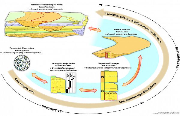
3 Groupement SONATRACH-AGIP, BP 475, Zone Industrielle Hassi Messaoud, Route de Ouargla, 30500, Algeria The Trias Argilo-Gréseux Inférieur (TAGI) Formation of the Berkine Basin, Algeria consists of a c.100m thick succession of laterally extensive alluvial sediments deposited within a series of NE-opening grabens, associated with the opening of the proto-Tethys Ocean. The succession is bound at its base by the Hercynian Unconformity and capped by a marine transgression resulting in the deposition of a mud-dominated coastal plain succession. The TAGI is subdivided into the Upper, Middle, Lower and Basal Members, each of which is characterised by fluvial rejuvenation, followed by gradual abandonment. A broadly NE-directed channel system is inferred throughout the evolution of the TAGI with changing climatic conditions, variations in sediment supply and accommodation space dictating the type of fluvial system and stacking patterns that ultimately influence sandbody connectivity and reservoir architecture.A multi field-scale study evaluating new and existing core, borehole image (BHI), wireline log, reservoir quality and production data, across 53 wells from Blocks 401/402 has allowed for a detailed investigation into the depositional evolution, resulting in the division of the TAGI into nine mapping layers. These layers best capture the large-scale variations in depositional and reservoir architecture. Within this sedimentological framework, the internal heterogeneity is captured through the evaluation of the plug-scale controls on reservoir quality, complemented by a detailed petrographical evaluation. The controls on reservoir quality include grain size, mud content and dolomite cementation. Evaluation in terms of the wireline log characteristics has established ranges in reservoir quality based on variations in the gamma ray (mud content and grain size) and bulk density response (% dolomite cements) respectively, thereby providing likely reservoir characteristics in the absence of conventional core analysis that are more intuitive than those based solely on log algorithms. The depositional architecture is constrained through assessment of the distribution of interpretive facies associations (ie. channels and crevasse splays), within an event-based correlation framework. However, whilst displaying a specific geometry that can be used for modelling purposes they are non-unique discriminators of reservoir quality, potentially covering four orders of magnitude in permeability. To combat this variation, this study has established a modelling approach using descriptive ‘building blocks’ termed depositional package groups (equivalent to rock types) to populate the known geometry of facies associations. These groups are characterised by lithology, bed-set scale heterogeneity, mud content and dominant sedimentary structure or post depositional fabric. Consequently they are at a scale that can be recognised on the wireline logs and display unique/semi-unique reservoir quality characteristics that effectively capture the internal reservoir architecture. The modelling approach considers each of the mapping layers in terms of the overall reservoir architecture and stacking patterns. Within this, the dimensions and orientations (depositional fairways) of the dominant channel-belts are defined based on varying channel sinuosity, as determined through the recognition and dominance of downstream vs. lateral accretion based on BHI evaluation. The vertical and spatial facies association distributions are displayed on facies maps conditioned by the fixed data points of the wells. The geometries of the individual facies associations appropriate to that mapping layer are then populated by the depositional package groups allowing for semi-deterministic modelling of the porosity and permeability trends and pore scale heterogeneity.


